| View previous topic :: View next topic |
| Author |
Message |
pato74
Joined: 26 Apr 2005
Posts: 17
|
|
| Back to top |
|
 |
gouldjg
Joined: 17 Mar 2005
Posts: 959
Location: Manchester UK
|
 Posted: Thu Apr 28, 2005 5:45 pm Post subject: Posted: Thu Apr 28, 2005 5:45 pm Post subject: |
 |
|
Just got it now. Cool tool
upto 3000 mtr range bearing tool, much better for plotting with.
Thanks for tip |
|
| Back to top |
|
|
Ghost Wolf
Joined: 05 Jul 2003
Posts: 74
Location: Texas
|
| Posted: Thu Apr 28, 2005 6:04 pm Post subject: |
|
|
wow that forum is awful
The amazing lack of knowledge of people there is shocking |
|
| Back to top |
|
|
Wolfar
Joined: 17 Mar 2005
Posts: 441
Location: Avondale, AZ
|
| Posted: Thu Apr 28, 2005 6:31 pm Post subject: |
|
|
| Ghost Wolf wrote: | wow that forum is awful
The amazing lack of knowledge of people there is shocking |
It is afterall refered to as the UBI Kiddie Playroom.  |
|
| Back to top |
|
|
Quillan
Joined: 20 Apr 2005
Posts: 299
|
| Posted: Thu Apr 28, 2005 7:06 pm Post subject: |
|
|
| Pato, that looks awesome, but I'm having a problem with it, and I'm not sure if it's the file or my installation of it. When I use it, the ranges are wrong, by a factor of 2. I used the scale bar in the bottom left of the nav map to draw a circle of 100 meters radius, and then moved that to the center of the new bearing tool. The outer circle was falling on the 200 meter line, rather than the 100 meter line. |
|
| Back to top |
|
|
pato74
Joined: 26 Apr 2005
Posts: 17
|
| Posted: Thu Apr 28, 2005 7:48 pm Post subject: |
|
|
| Quillan wrote: | | Pato, that looks awesome, but I'm having a problem with it, and I'm not sure if it's the file or my installation of it. When I use it, the ranges are wrong, by a factor of 2. I used the scale bar in the bottom left of the nav map to draw a circle of 100 meters radius, and then moved that to the center of the new bearing tool. The outer circle was falling on the 200 meter line, rather than the 100 meter line. |
It's working fine with me, anyone else have this problem??
S!
Pato |
|
| Back to top |
|
|
jmr
Joined: 24 Sep 2004
Posts: 296
|
| Posted: Thu Apr 28, 2005 8:47 pm Post subject: |
|
|
edit: ok I downloaded it and renamed the file with a .zip extension and so now I can open it.
The screenshots look great and makes me wish that somehow a stationary manueveringboard could be incorporated into the game. |
|
| Back to top |
|
|
Quillan
Joined: 20 Apr 2005
Posts: 299
|
| Posted: Thu Apr 28, 2005 10:00 pm Post subject: |
|
|
Here's what I get:

It's gotta be either a bad extraction, bad download, or something on my computer/program doing this, but I can't figure out what. I thought I might have goofed something in the maps.cfg file, so I restored the backup, and nothing changed. I extracted the file again, and got the same result. One question. Your first overlay was nearly 10 megs. This one is only 7. Is that correct? |
|
| Back to top |
|
|
wazoo
Joined: 27 Jan 2005
Posts: 247
Location: Tustin, California
|
| Posted: Thu Apr 28, 2005 11:53 pm Post subject: |
|
|
| pato74 wrote: | | Quillan wrote: | | Pato, that looks awesome, but I'm having a problem with it, and I'm not sure if it's the file or my installation of it. When I use it, the ranges are wrong, by a factor of 2. I used the scale bar in the bottom left of the nav map to draw a circle of 100 meters radius, and then moved that to the center of the new bearing tool. The outer circle was falling on the 200 meter line, rather than the 100 meter line. |
It's working fine with me, anyone else have this problem??
S!
Pato |
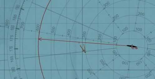
Yup. I'm having the same problem. If I draw a line out to the edge of the Bearing circle, I show 1.5km and NOT 3.0.
Here's a picture with a compass out to .8km on the 1.6km bearing mark:

I changed the maps.cfg to what the Readme says but still get this problem.
Also... don't know if this is relevant or not, but your README says to change SymbolZoom from 5 to 20.... but my SymbolZoom is 10 to begin with.
Interesting....
Wazoo |
|
| Back to top |
|
|
Wolfiesden
Joined: 26 Apr 2005
Posts: 51
Location: Milwaukee, WI
|
| Posted: Fri Apr 29, 2005 12:53 am Post subject: Re: SH3 Bearing overlay 3.0 |
|
|
| pato74 wrote: | http://forums.ubi.com/eve/ubb.x?a=tpc&s=400102&f=9091085392&m=5431068603
scroll down
S!
Pato |
Awesome! Thats the cat's ass right there 
Now with that and the compass mouse cursor (replaces the mouse cursor for the divider compass) I made, you can do some serious plotting quickly! You can get the compass.tga here: http://www.wolfiesden.com/games/SH3/Files/ I used the bearing ring from the map tools mod and combined it with the compass tool icon. Below you can see I have plotted the course of the ship as approx 100 degrees and range is about 2850m and is about 7 degrees to starboard. Given that, I should be able to turn to 190 full stop and wait and she should cross my bow at about 800m out. Christ! I might be able to hit something on manual now!
 |
|
| Back to top |
|
|
microdiver
Joined: 18 Mar 2005
Posts: 276
|
| Posted: Fri Apr 29, 2005 3:48 am Post subject: |
|
|
The old one was off by 1 degree in the nav map. If you were following a plotted course the line would be at 359'. Has that been fixed in this one?
Strangly it was OK on the TDC screen. |
|
| Back to top |
|
|
cavalier889
Joined: 03 Dec 2004
Posts: 504
Location: Albuquerque NM
|
| Posted: Fri Apr 29, 2005 5:54 am Post subject: |
|
|
| wazoo wrote: | | pato74 wrote: | | Quillan wrote: | | Pato, that looks awesome, but I'm having a problem with it, and I'm not sure if it's the file or my installation of it. When I use it, the ranges are wrong, by a factor of 2. I used the scale bar in the bottom left of the nav map to draw a circle of 100 meters radius, and then moved that to the center of the new bearing tool. The outer circle was falling on the 200 meter line, rather than the 100 meter line. |
It's working fine with me, anyone else have this problem??
S!
Pato |
Yup. I'm having the same problem. If I draw a line out to the edge of the Bearing circle, I show 1.5km and NOT 3.0.
Here's a picture with a compass out to .8km on the 1.6km bearing mark:
I changed the maps.cfg to what the Readme says but still get this problem.
Also... don't know if this is relevant or not, but your README says to change SymbolZoom from 5 to 20.... but my SymbolZoom is 10 to begin with.
Interesting....
Wazoo |
I'm just taking a shot in the dark here, but in your map.cfg, under the heading [map0], does your resolution line look like this?
Resolution=1024,656
With so many mods running around, it's hard to know what's changed and what's not. Also, are you using the res fix? and if so, at what resolution? |
|
| Back to top |
|
|
Cpt. Evans
Joined: 10 Jan 2002
Posts: 8
|
| Posted: Fri Apr 29, 2005 7:47 am Post subject: |
|
|
| I had this problem with the previous version of the bearings-range-circles addon. Before I installed this latest version, I removed all .tga file associations (I have an image viewer called IrfanView which, by default, can open .tga files). The new bearing/range circles version works just fine now. Could this be part of the solution? |
|
| Back to top |
|
|
Quillan
Joined: 20 Apr 2005
Posts: 299
|
| Posted: Fri Apr 29, 2005 8:17 am Post subject: |
|
|
| I suppose it could. I don't have Irfan, but all my .tga files open with my old copy of Photoshop 5.0. I might try erasing the file association and see. |
|
| Back to top |
|
|
pato74
Joined: 26 Apr 2005
Posts: 17
|
| Posted: Fri Apr 29, 2005 8:58 am Post subject: |
|
|
| cavalier889 wrote: |
I'm just taking a shot in the dark here, but in your map.cfg, under the heading [map0], does your resolution line look like this?
Resolution=1024,656
With so many mods running around, it's hard to know what's changed and what's not. Also, are you using the res fix? and if so, at what resolution? |
I was thinking the same thing about the resolution mod so I tested and it made no difference, as for my map.cfg here is what i have:
[Map0]
MapID=Navigation_map
Position=0,0
Resolution=1024,656
MajorSqrs=4,2.4
MinorSqrs=5,5
PixPerUnit=50
ZoomLevels=1,2,5,10,20,50,100,200,500,1000,2000,4000,10000,20000,40000; meters per pixel
InitialZoom=500
SymbolZoom=20;units are drawn as symbols from this zoom up
GroupsZoom=100;units are drawn in groups from this zoom up
CityZoom=10000;city names are displayed from this zoom down
KriegZoom=2000;krieg labels are separated displayed from this zoom up
I'm particularly suspicious of PixPerUnit=50 value, this have to, in some way, control the scale of the map.
Those who are having trouble with different scales can confirm this? |
|
| Back to top |
|
|
|
|
You cannot post new topics in this forum
You cannot reply to topics in this forum
You cannot edit your posts in this forum
You cannot delete your posts in this forum
You cannot vote in polls in this forum
|
Powered by phpBB © 2001, 2005 phpBB Group
|